

Contractors
Enhance Your Projects with Advanced Drone Services while maintaining safety and efficiency
Detailed Roof and Facade Inspections and Measurement
Accurate and detailed roof measurements and inspections using high-resolution drone imaging. Identify potential issues early and ensure precise project planning and execution. Get more accurate insights and planning material without the need to send your workers in dangerous situations.

Solar Panel Inspection
Enhance your instalment services by offering solar panel inspections to ensure home owners solar panels are operating at their peak efficiency with Aerial Informatic' advanced drone inspection services. Our cutting-edge technology provides detailed insights into the condition of solar panels, helping you gain services from recurring clients.

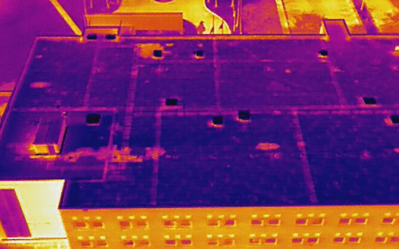
Thermal Imaging
Detect heat anomalies and potential failures in electrical systems, pipelines, and other critical infrastructure with advanced thermal imaging. This technology helps prevent costly breakdowns by identifying overheating components and areas needing immediate attention.
Detailed Inspections
Utilize high-resolution imaging and video to conduct thorough inspections of your infrastructure and assets. Our advanced drone technology ensures all details are captured accurately, enabling you to identify and address potential issues before they become major problems.

Progress Updates for Shareholders
Photos, videos, and 3D models that can be accessed virtually globally for sharing with clients and stakeholders throughout the entire construction process of a development.

BIM Integration
The lack of precise position data makes it difficult to align BIM designs, road vector maps, and satellite imagery, costing time and labor. 2D designs are unable to illustrate the spatial information required to fully visualize the design. Our services create 3D models with accurate positioning data that can be readily fitted into BIM models to visualize designs. Designs can be optimized using drone-created 3D models that are compatible with a variety of GIS software

Our methods collect significantly more data points than traditional surveying techniques, ensuring greater precision in measuring distances, elevations, and structural features. Additionally, drone surveys are faster and less labor-intensive, reducing the time and workforce required for site preparation, progress tracking, and quality control, ultimately increasing efficiency and accuracy in construction projects.

High Precision Survey Mapping
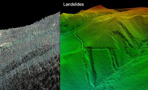
DEM
Digital Elevation Models are used as a digital depiction of the topography of surveyed terrains. Scanning an area with a LiDAR sensor quickly yields results, showing terrain variation such as slopes, water logged areas, drainage issues and more. This service is ideal for large properties dealing with flooding, drainage and other terrain centered issues
Excavation and Groundworks
In excavation and groundworks, our technologies can accurately measure and calculate cut-and-fill volumes and enable precise measurement of stockpile volumes. Additionally, detailed and variable rate assessments of areas, gradients, and contours. This technology streamlines the entire excavation process, enhancing efficiency, accuracy, and communication with team members and customers.

Progress Monitoring

Enhance your construction project management with our advanced drone-based progress monitoring services. Our services provide regular as-built updates of your site in both 2D and 3D, allowing you to visualize, measure, and track changes remotely at all project stages. By comparing as-built models with as-designed plans, you can identify errors early, avoiding costly rework and schedule deviations. Create a digital record of your project organized chronologically, enabling you to go back in time to verify progress and resolve disputes. Our service ensures you stay on top of logistics and project timelines, with accurate, on-demand 2D maps and 3D models to track dynamic changes and daily progress. Easily export data into CAD and GIS software, streamlining your workflow and enhancing project planning and execution. Overcome the limitations of traditional monitoring methods with our comprehensive, detailed aerial surveys, and keep your project on track with ease.