Engineering Services
Our services used in engineering are a great way to enhance practices, cut costs, streamline processes, and increase efficiency. The insights available are valuable in many ways, giving engineers a multi-dimensional utility across the specialties.
BIM Integration
The lack of precise position data makes it difficult to align BIM designs, road vector maps, and satellite imagery, costing time and labor. 2D designs are unable to illustrate the spatial information required to fully visualize the design. Our services create 3D models with accurate positioning data that can be readily fitted into BIM models to visualize designs. Designs can be optimized using drone-created 3D models that are compatible with a variety of GIS software

Our methods collect significantly more data points than traditional surveying techniques, ensuring greater precision in measuring distances, elevations, and structural features. Additionally, drone surveys are faster and less labor-intensive, reducing the time and workforce required for site preparation, progress tracking, and quality control, ultimately increasing efficiency and accuracy in construction projects.

High Precision Survey Mapping
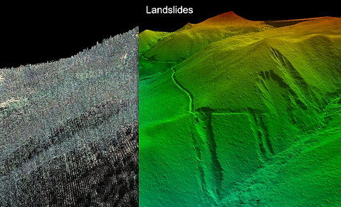
DEM
Digital Elevation Models are used as a digital depiction of the topography of surveyed terrains. Scanning an area with a LiDAR sensor quickly yields results, showing terrain variation such as slopes, which can then be considered in the planning process by civil engineers. This is ideal for detecting potential issues when building infrastructure like roads or railways.


Tunnel Surveying
LiDAR is an ideal solution for capturing data from tunnels. Accurate and detailed 3D point clouds can be used to analyse, assess, or model a tunnel. Being able to depict imperfections in a tunnel, highlighting potential structural issues. As well as being able to be accurately geographically positioned with terrain surveys.
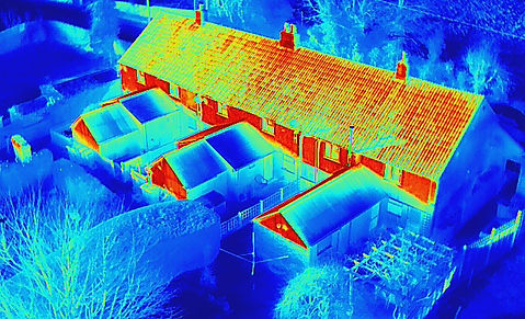
Thermal Inspection
Asses the health of a building with FLIR aerial thermography. Get insights into leakage, moisture, insulation problems. This technology allows you to analyze geographically tagged thermal images to help prevent problems before they get worse.