

Homeowners
Enhance renovations with 3D features and maintain preventative planning of your home.
Rennovation and Planning
At Aerial Informatics, we understand that visualizing and planning construction projects can be an expensive endeavor, especially when relying on traditional architectural services. Our advanced drone and 3D modeling technology offers a cost-effective alternative that not only saves you money but also enhances the precision and efficiency of your project visualization.

Opting for Aerial Informatics advanced visualization services means you can achieve your project goals with greater accuracy, efficiency, and cost-effectiveness. Save money on expensive architect fees and enjoy the benefits of cutting-edge technology for all your construction and renovation projects.
Visualizing Additions
Visualizing additions with 3D models allows homeowners and architects to see exactly how new elements will integrate with existing structures. These models provide a realistic preview of the addition's size, style, and impact on the overall aesthetic. This technology aids in identifying potential design issues, optimizing space usage, and ensuring that the new addition complements the original design. It also facilitates better communication and decision-making, as all contractors can clearly understand and provide input on the proposed changes.

Interior Design Layouts
Our services allow homeowners to model spaces accurately, experiment with different layouts, and visualize materials and lighting in real-time. Clients can take virtual tours of the proposed designs, making it easier to understand and approve concepts. This technology enhances creativity, improves communication, and streamlines revisions, resulting in more effective and efficient interior design projects.

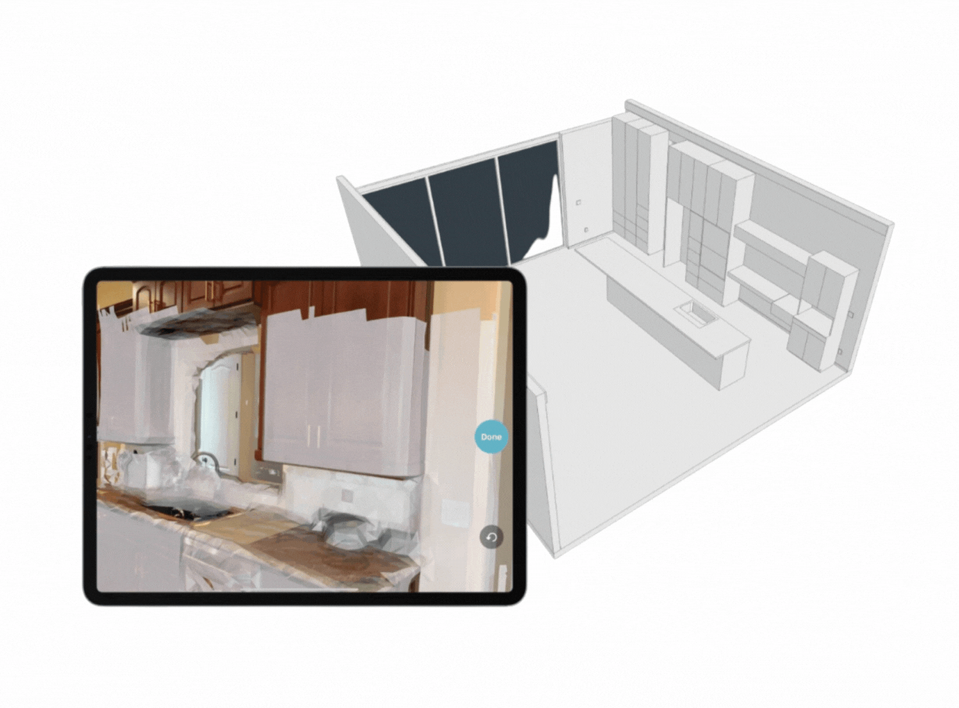
Multidimensional Blueprinting
Blueprinting using our 3D tools revolutionizes architectural design. LiDAR captures precise measurements of physical spaces, creating accurate 3D models. These scans can be converted into detailed 2D and 3D blueprints, allowing homeowners to visualize and modify designs effortlessly. This technology streamlines planning, enhances accuracy, and facilitates better communication.

3D renderings
3D renderings enhanced by AI enhance creativity in interior design by offering unique design suggestions, rapid experimentation, and realistic previews. AI analyzes trends and materials, providing innovative ideas and allowing designers to visualize multiple options quickly. By automating routine tasks, time for creative work fosters better collaboration with architects ensuring the final design aligns perfectly with your vision.
Health Diagnosis of Properties
Your home is your sanctuary, and ensuring it is a healthy environment is essential for your well-being. At Aerial Informatics, we provide advanced drone and inspection services that offer comprehensive health insights into your home, helping you maintain a safe and comfortable living space.
Health diagnosis of properties involves a thorough examination using advanced technologies to assess the overall condition of a building. This process includes checking structural integrity, identifying potential hazards, and evaluating systems like plumbing and HVAC. By providing a detailed report on a property's health, this service helps owners understand maintenance needs and avoid unexpected repairs, ensuring a sound investment.
Thermal Imaging
Detect heat anomalies and potential failures in electrical systems, pipelines, and other critical infrastructure with advanced thermal imaging. This technology helps prevent costly breakdowns by identifying overheating components and areas needing immediate attention.
Asses the health of your home with FLIR aerial thermography. Get insights into leakage, moisture, insulation problems. This technology allows you to analyze geographically tagged thermal images to help prevent problems before they get worse.


Solar Panel Inspection
Ensure your solar panels are operating at their peak efficiency with Aerial Informatics' advanced drone inspection services. Our cutting-edge technology provides detailed insights into the condition of your solar panels, helping you maximize energy production and maintain a sustainable home.

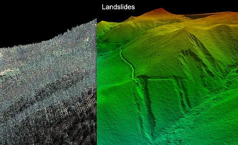
DEM
Digital Elevation Models are used as a digital depiction of the topography of surveyed terrains. Scanning an area with a LiDAR sensor quickly yields results, showing terrain variation such as slopes, water logged areas, drainage issues and more. This service is ideal for large properties dealing with flooding, drainage and other terrain centered issues
Detailed Roof and Facade Inspections
Ensure the integrity and longevity of your building with Aerial Informatics advanced drone inspection services. Our high-resolution imaging captures detailed pictures of your roof and facade, allowing us to identify issues such as cracks, leaks, and wear. Our drone inspections are conducted quickly and safely, eliminating the need for scaffolding or ladders, ensuring the safety of your property and personnel.
Multispectral Analysis for Vegetation
Multispectral analysis provides a detailed assessment of your property's vegetation health. This technology detects plant stress, disease, and nutrient deficiencies, offering you and potential buyers a comprehensive view of the landscape's condition. Highlighting healthy, well-maintained vegetation can significantly boost a property's appeal and value, making it more attractive to prospective buyers.


Digital Twinning
Interior and exterior digital twins are precise virtual replicas of buildings, capturing every detail from structure to decor. These tools enable homeowners and architects to visualize modifications, optimize designs, and predict performance without being onsite. Enhance collaboration, streamline project management, and make informed decisions with accurate, immersive digital twins.
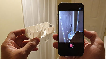
3D prototyping
3D printing revolutionizes architectural prototyping by creating precise physical models of designs. This technology allows homeowners to visualize and test structures, materials, and layouts in a tangible form, enhancing understanding and communication with contractors. Rapid prototyping accelerates the design process, reduces costs, and helps identify potential issues early, ensuring more efficient and accurate project development.
Drone videography and Photography
Drone photography and videography offer dynamic and captivating views of properties. This technology provides aerial perspectives that highlight property features, surrounding landscapes, and neighborhood amenities in stunning detail. High-quality drone footage enhances marketing efforts, attracts potential buyers, and provides a comprehensive visual experience that static images cannot match.


Event planning
Plan your event with detailed layouts of real environments. Whether you're organizing an interior wedding or an exterior corporate charity event, our detailed layouts of real environments ensure your event is executed flawlessly.
